GPS Navigation:Street View Map
- 0.0
- Rating
- 10.00K
- Installs
- Free
- Price
 Analysis by App-foxy
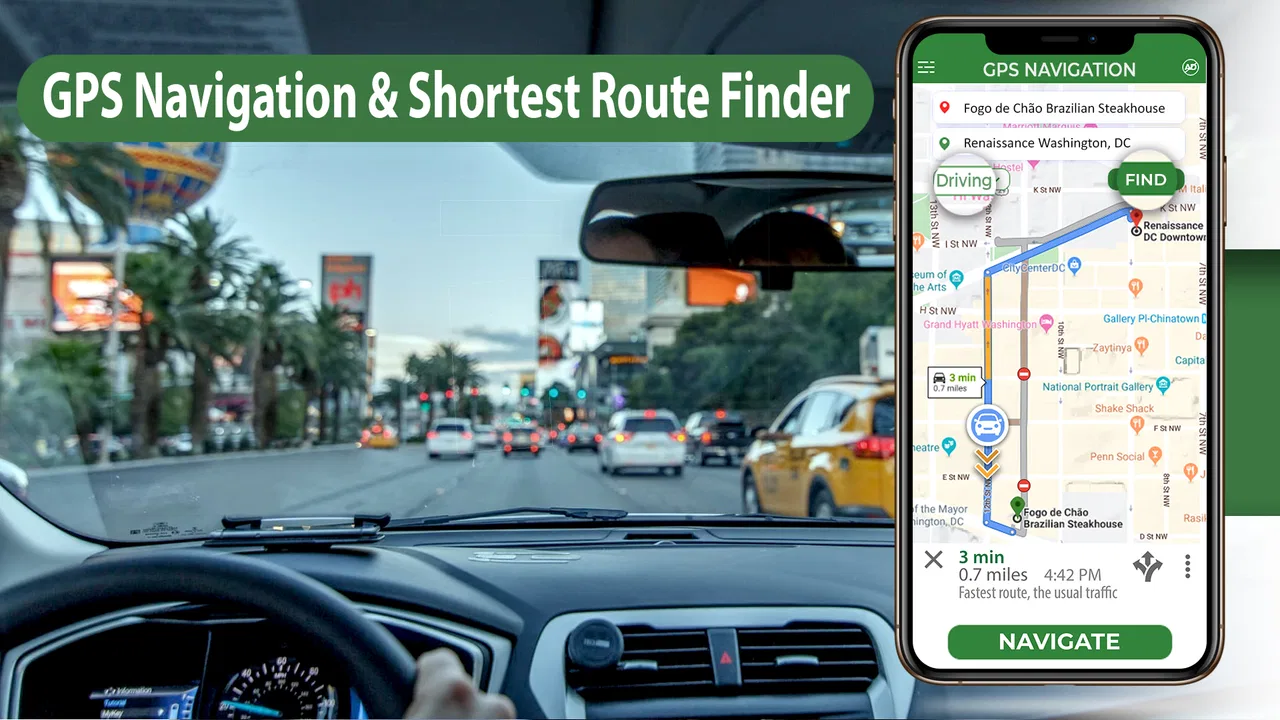
GPS Navigation:Street View Map is the kind of Android navigation app I would open when I want more than a line drawn across a map. Its main appeal is the combination of route guidance, map browsing, and street-view-style visual checking, which can make an unfamiliar destination feel more recognizable before I arrive. I found that this changes the experience most when I am approaching a place I have never visited: instead of relying only on a turn instruction, I can use the surrounding streets and buildings as visual context.
That focus makes it different from a navigation tool designed purely to get me from point A to point B. I see it as a practical companion for checking an address, understanding the final approach, and gaining confidence in an unfamiliar area. It is free to install, aimed at Everyone, and developed by Technest Apps. The app has passed the early discovery stage with over ten thousand installs, while optional in-app purchases range from two dollars and ninety-nine cents to forty-nine dollars and ninety-nine cents per item.
Street-level context is the capability that matters most
The most useful idea here is not simply showing a route. It is giving me a chance to inspect the destination and its surroundings visually. A normal map can tell me that a road turns left or that an address sits beside an intersection. A street-view presentation can help answer the more practical question: what will this place look like when I actually get there?
You May Also Like

 Blood Strike: 2.5 Anniversary
Blood Strike’s Loadouts Turn Every Drop Into a Tactical Gamble
A close look at Blood Strike’s custom loadouts: how fast access to signature weapons reshapes its battle royale rhythm, rewards preparation, and narrows the gap between fights.

 Pandora - Music & Podcasts
Pandora’s Music Is Easy to Start, but Harder to Recover
Pandora’s strength is its low-effort path from a seed to a station. Its weak spot is how much confidence it asks you to place in connection, setup, and quiet recovery.

 8 Ball Pool
 Is Built on Rivalries, Rematches, and Routine
A close look at the rivalries, rematches, shared routines, and unanswered safety questions that turn a quick pool match into a persistent mobile community.

 Samsung Music
’s Quiet Strength Is Playing What You Already Own
Its reach comes less from spectacle than from dependable access to a personal library. That simplicity is both the app’s strongest retention engine and its ceiling.

 AccuWeather: Weather Radar
AccuWeather Review: A Quick, Clear Forecast for Everyday Decisions
For everyday plans, the best forecast is the one you can understand quickly. AccuWeather makes rain timing, radar, and local conditions easy to act on, with a few trade-offs.

 Hill Climb Racing
Why Hill Climb Racing Still Turns Crashes Into One More Run
A tiny car, a bumpy hill and one more upgrade: Hill Climb Racing keeps resurfacing because its simple chaos makes every near-miss feel personal.
More From Our News Desk
View All News


That distinction matters in everyday situations. If I am meeting someone at a large building, visiting a business in a row of similar storefronts, or arriving at a residential street with several entrances, a visual preview can reduce the final-minute uncertainty that ordinary directions often leave behind. I can look for the shape of the road, nearby buildings, and recognizable surroundings rather than depending entirely on a written address.
I also like this capability for planning a route before leaving. Looking at the destination first can reveal whether the final approach seems straightforward or whether I should allow extra attention for a complicated junction. It does not replace sensible navigation, but it gives the trip a more concrete starting point. In my experience, that is where the app feels more valuable than a basic map viewer.
The app belongs to the Maps & Navigation category, but I would not judge it only by the number of navigation controls it offers. Its strongest identity is visual orientation. The route is important, yet the surrounding view is what can make a route easier to understand. That is a narrower promise than being the best all-purpose navigation service, but it is also easier to appreciate when the destination itself is the difficult part.
What the visual approach changes during a trip
Turn-by-turn directions are excellent when I already understand the area. They become less reassuring when I am approaching an unfamiliar address and need to identify the correct entrance, side street, or building. In that moment, visual context works like a memory aid. I can connect what I saw on the screen with what appears through the windshield or along the pavement.
This is especially helpful for walking the last part of a journey. A map pin may be accurate enough to show the general location, but it does not always make the entrance obvious. Checking the surroundings beforehand can help me avoid walking around a block, entering from the wrong side, or mistaking a nearby road for the destination street. I would still verify signs in person, but the preview gives me a better mental picture.
There is also a useful distinction between browsing and active navigation. I can use the app before starting a trip simply to understand an area, without treating it as my only driving assistant. That makes it suitable for planning a visit, checking a meeting location, or getting familiar with a route before I leave home. The app’s value is therefore not limited to the minutes when I am moving.
How I would use it in practice
I would begin by searching for the destination and checking the broader map first. This prevents me from focusing on a single image while missing the relationship between the destination, nearby roads, and the route leading there. Once I understand the general position, I would move closer and inspect the street-level view around the final approach.
My next step would be to look for practical landmarks rather than trying to memorize every detail. A distinctive corner, a bend in the road, a nearby building, or the direction of the entrance is more useful than a long list of visual details. The goal is not to study the entire neighborhood. It is to create two or three recognition points that can help me confirm that I am close.
For a driving trip, I would do this while parked or before starting. I would not treat visual browsing as something to operate continuously while moving. That is an important trade-off: the feature is helpful for preparation, but safe driving still requires attention to the road and appropriate use of the phone. For walking, I would also check the route before moving and then use the screen briefly rather than staring at it throughout the journey.
A small but useful workflow is to compare the destination view with the address details before leaving. If the pin appears near a large complex or a road with several possible approaches, I would note which side seems most likely to contain the entrance. This can save time later, particularly when arriving for an appointment and not wanting to circle around looking for the correct access point.
A realistic everyday scenario
Imagine I am visiting a clinic, office, or service location in a part of town I rarely use. The written address may be correct, but the building could face a side road while the main road passes behind it. Before leaving, I would open the location, inspect the surrounding streets, and use the visual view to identify the building’s position relative to the road. I would then pay attention to the final turn and the likely entrance.
When I arrive, I am not searching from scratch. I already have a rough picture of the approach, so I can concentrate on road signs, parking, and pedestrians. If the entrance is not immediately visible, the surrounding landmarks give me a better basis for deciding whether I am in the right place. This is the kind of small improvement that can make the app feel genuinely useful even when the trip itself is short.
The same method works for meeting a friend near a busy commercial area. Instead of saying only “I am at the pin,” I can use the map and visual context to understand which corner or frontage is relevant. It does not solve every meeting-point problem, but it can reduce the vague back-and-forth that happens when two people are standing on different sides of the same location.
Where it compares well with usual alternatives
A conventional map app often wins when I need a broad ecosystem: live traffic, public transport information, saved places, business details, or deep integration with other services. A dedicated navigation platform may also be the better choice for long drives where constantly updated road conditions and highly refined route adjustments are the priority.
GPS Navigation:Street View Map has a different advantage. I would choose it when visual orientation is more important than managing a large collection of travel services. The street-level perspective can be more immediately useful than a plain overhead map when I am trying to recognize a destination. In that sense, it complements rather than completely replaces the usual alternatives.
It is also more focused than opening a general map and hoping that the relevant visual tools are easy to find. The app puts its identity around navigation and street-view map exploration, so I can approach it with a specific task in mind: understand the route, inspect the destination, and prepare for the final approach. That focus is helpful for users who do not need a full travel-planning platform every time they open a map.
On the other hand, I would not pick it as my sole navigation solution for every journey. If my priority is changing traffic conditions, detailed transit planning, or a mature set of location-management tools, a larger mapping service may be more appropriate. The right choice depends on whether I need visual familiarity or a complete transportation dashboard.
Practical trade-offs before relying on it
The first trade-off is that a visual preview can create confidence without guaranteeing that the scene will look exactly the same when I arrive. Buildings, signs, vehicles, construction, weather, and temporary changes can alter the view. I treat street-level imagery as orientation, not as a promise that every visible detail will still be present.
The second trade-off is attention. Browsing a detailed map takes more concentration than following a simple instruction. That is an advantage before a trip, but it can become a distraction if I try to explore while driving. My preferred routine is to inspect the destination in advance, start the journey prepared, and only interact with the phone when safely stopped.
The third trade-off concerns expectations around the free offering. The app itself is free, but optional purchases are available, with individual items priced from two dollars and ninety-nine cents up to forty-nine dollars and ninety-nine cents. I would check what a purchase unlocks before confirming anything and begin with the free experience to see whether it covers my normal use. That is particularly sensible for someone who only needs occasional destination checks.
Another point is device compatibility. The current version is 2.7, and the app requires Android 9 or later. For people using an older phone or an older Android release, that requirement is worth checking before planning around the app. On a supported device, I would still test the experience on a short local trip first, because navigation comfort depends on screen size, responsiveness, and how easily I can read the map while stationary.
The app was released on December 18, 2020, and its developer is Technest Apps. Those details do not determine whether it suits me, but they provide useful context when I think about expectations. I would approach it as a focused navigation and visual-location tool rather than assuming it offers every feature found in the largest mapping products.
Tips that make the visual feature more useful
My first tip is to inspect the destination from more than one direction. The approach that looks obvious on the overhead map may not be the entrance I need. Rotating the perspective or checking the nearby streets can reveal that the building is easier to reach from a side road. This is a simple habit, but it prevents me from confusing “near the destination” with “at the correct entrance.”
My second tip is to use the visual view for recognition, not decoration. I would deliberately choose one fixed landmark before leaving, such as a corner, a building outline, or a distinctive road shape. When I arrive, that landmark becomes a confirmation point. This is more reliable than trying to remember an entire screen full of details.
My third tip is to separate route planning from route following. I would explore the map while I have time, then close the planning task before setting off. This reduces the temptation to make last-second visual searches during a busy section of road. It also helps me notice whether the destination itself, rather than the route, is likely to be the main source of confusion.
A fourth useful habit is to prepare for the final few minutes, not just the whole journey. Long routes are often easy until the last turn. I would spend most of my visual checking on the destination street, nearby intersections, and possible entrance area. That is where the app’s street-view emphasis can deliver the biggest practical benefit.
Who will gain the most from it
I think the app is best for people who regularly visit unfamiliar addresses and prefer visual reassurance. New residents exploring a city, occasional drivers, delivery-style visitors, travelers checking a meeting point, and pedestrians navigating the final block can all benefit from seeing more than a pin and a route line.
It may also suit someone who feels comfortable with maps but struggles with the last step of identifying a building. The app does not need to replace a familiar navigation service in that case. It can act as a preparation tool: open it before leaving, understand the surroundings, and then use whichever navigation method feels safest during the trip.
I would be more cautious about recommending it to someone who wants one app to manage every type of transport and travel detail. Users who depend on advanced traffic intelligence, extensive transit planning, or a large personal location library may find a broader alternative more efficient. Likewise, anyone on an unsupported Android version should not make it part of a travel plan without first confirming that the device can run it.
For occasional use, the free starting point makes the decision fairly easy. I would install it, test a familiar destination, then compare how quickly I can understand an unfamiliar one. If the street-level perspective helps me recognize places faster, it has earned a place alongside my usual map app. If I only need basic directions and never inspect destinations visually, its central capability may not add enough value.
My final view after using the approach
GPS Navigation:Street View Map is most convincing when I use it as a visual preparation tool rather than expecting it to be an all-purpose replacement for every mapping service. The combination of directions, maps, and street-level context gives me something practical: a clearer idea of what the destination and final approach may look like.
Its limitations are tied to that same focus. Visual information needs sensible interpretation, interaction should happen before driving or while safely stopped, and users should review optional purchases rather than assuming everything is included at no cost. Those are manageable considerations, but they matter when deciding how to use the app responsibly.
My recommendation is straightforward: if unfamiliar destinations make you hesitate, try it for the visual preview alone. The strongest reason to keep it installed is the extra confidence it can give during the final approach. If your needs center on live traffic, public transportation, or a complete travel-management system, a larger alternative may serve you better. For checking places, recognizing surroundings, and turning an abstract route into something I can picture, this free navigation app has a useful and specific role.
FAQs for GPS Navigation:Street View Map
01What is GPS Navigation: Street View Map used for?
GPS Navigation: Street View Map is designed to help users plan routes, find locations, explore maps, and navigate with location-based guidance. It may also include street-view imagery, map layers, nearby-place searches, and satellite or terrain views, depending on the device and available services. It is useful for checking an unfamiliar area before traveling, although users should still verify directions and road conditions.
02Does GPS Navigation: Street View Map work without an internet connection?
The application generally relies on an internet connection to load current maps, street imagery, search results, traffic information, and route data. Some navigation features may continue working temporarily after a route has loaded, but this should not be treated as full offline navigation unless the app clearly provides downloadable maps. Before traveling, check whether your destination and map area can be saved for offline use.
03Does the app require access to my location and other permissions?
Yes, turn-by-turn navigation and location-based searches normally require access to your device’s location services. The app may also request permission to use mobile data, notifications, or storage for map-related functions. You can review and change these permissions in Android or iOS settings. For better privacy, allow location access only when needed and check the app’s privacy policy before using additional features.
04Are the maps, directions, and street-view images always accurate?
Map information can be helpful, but it is not guaranteed to be completely accurate or up to date. Roads may change, businesses can move or close, speed limits may be incorrect, and street-view images can be older than the current conditions. Weather, construction, traffic restrictions, and private roads may also affect a route. Always follow official road signs and local regulations instead of relying exclusively on the app.
05Is GPS Navigation: Street View Map free to download and use?
The app may be available as a free download, but some features can depend on advertising, in-app purchases, subscriptions, or limits imposed by the developer. Premium options may include an ad-free experience, enhanced map layers, advanced route tools, or additional location content. Review the store listing carefully before downloading and check the purchase screen so you understand any recurring charges or trial terms.
Pros
- Clear turn-by-turn directions for everyday driving
- Street View helps preview unfamiliar roads and locations
- Useful map search for nearby places and services
- Supports route planning before starting a trip
- Simple interface that new users can learn quickly
Cons
- Navigation accuracy may vary in rural or newly developed areas
- Street imagery may be outdated in some locations
- Some features may require an internet connection
- Advertising can interrupt the browsing experience
- Battery and mobile data usage may increase during long trips

GPS Navigation:Street View Map
Gallery